Tropical Storm Edouard Makes Landfall on Texas-Louisiana Gulf Coast
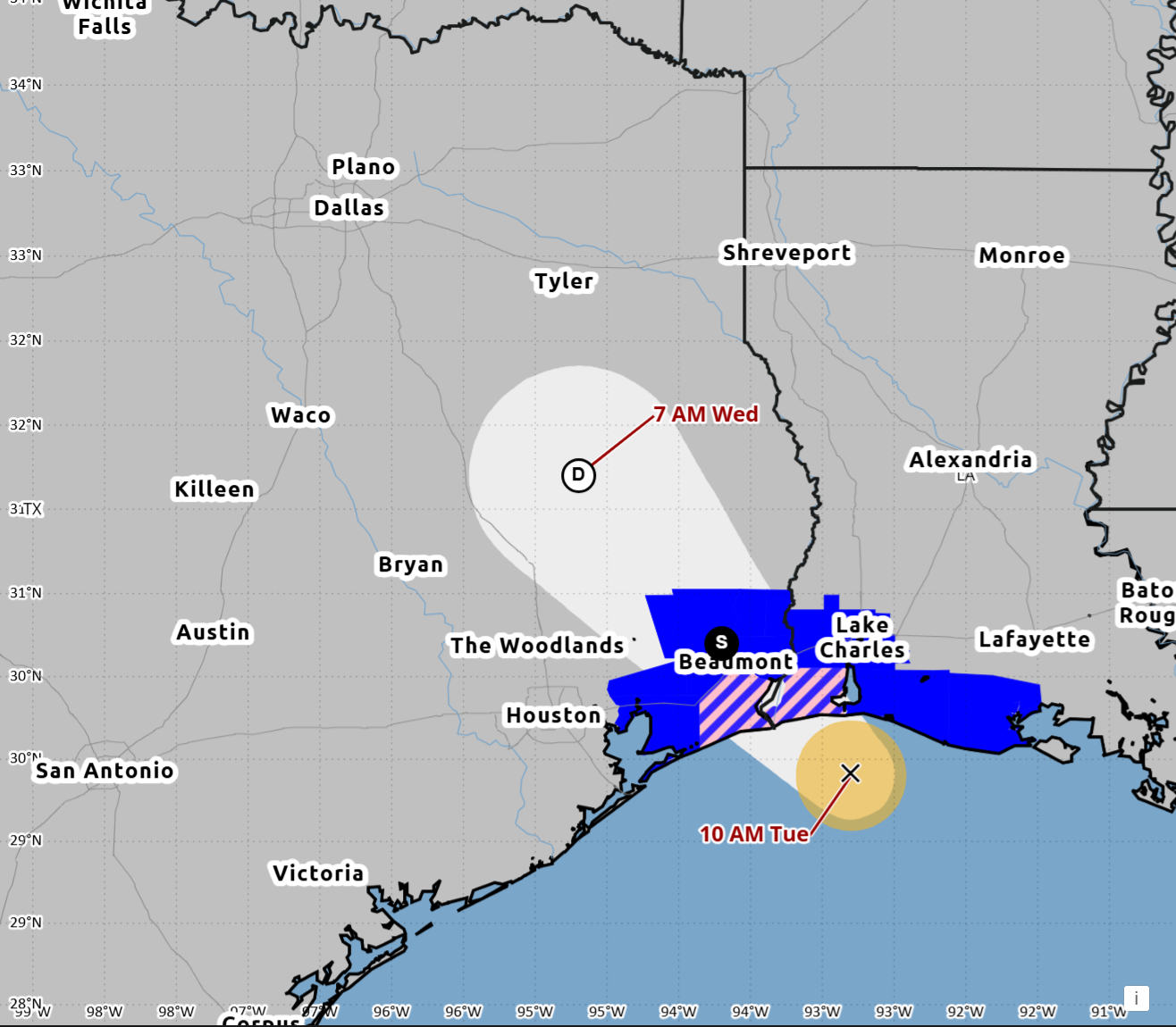
Tropical Storm Edouard made landfall Tuesday afternoon near Johnson Bayou, Louisiana, approximately 15 miles south-southeast of Port Arthur, Texas, bringing maximum sustained winds of 60 mph and heavy rainfall to the Gulf Coast region, according to Houston Public Media.
The storm, which crossed the coast at approximately 2:20 p.m. CDT on September 1, weakened to a tropical depression by Tuesday evening with maximum sustained winds of 35 mph. The National Hurricane Center issued its final advisory early Wednesday, transferring responsibility for monitoring to the Weather Prediction Center, which warned of significant flash flooding as the system tracked slowly inland across east-central Texas.
Fifth Named Storm of the 2026 Season
Edouard was the fifth named storm of the 2026 Atlantic hurricane season and the third tropical storm to make landfall along the U.S. Gulf Coast this year, following Arthur near Matagorda Bay in June and Bertha, which made two landfalls along the Gulf Coast in late August. The season has been quieter than normal due to an El Niño weather pattern that has suppressed most storm development.
Widespread Power Outages
Entergy reported more than 60,000 customers without power Tuesday night across its service area, which spans from The Woodlands to Beaumont. By Wednesday morning, that number had grown to over 77,000 customers across 10 counties in East Texas, according to USA Today. Jefferson County was hardest hit with 28,647 customers affected. CenterPoint Energy, which services much of the Houston area, reported just over 200 customers without power.
Flash Flood Threat Persists
The region faced significant flood risks as the storm’s remnants continued to produce heavy rainfall. The Weather Prediction Center forecast storm-total rainfall of 4 to 8 inches along Edouard’s path, with localized totals near 12 inches, as The Watchers reported. Most areas east of I-45, including Harris and Galveston Counties, were under a flood watch through Wednesday evening.
“With any tropical system, you could get some gusty winds, especially near the coast and offshore,” Brian Kyle, an NWS meteorologist, told Houston Public Media. “For those folks further inland, metro area and northward, we are looking more of a rainfall impact.”
Officials Urge Caution
State and local officials activated emergency operations ahead of the storm. Governor Greg Abbott activated 20 state agencies and 1,500 state-level personnel, along with rescue aircraft, swift water rescue boats, and high-water vehicles. Houston Mayor John Whitmire said his administration was “better prepared today than ever in Houston’s history,” pointing to a buildout of backup power generators at city facilities following Hurricane Beryl.
Brian Mason, Houston’s top emergency management official, urged residents to stay off the roads. “Please pack your patience if you’re out and about, and please do not drive through ponded water,” Mason said. “Most importantly, unless you really need to be somewhere this evening and tonight, please stay off the road.”
Beaumont Mayor Roy West preemptively signed a disaster declaration Tuesday afternoon. “We’re very well prepared for anything that may occur,” he said in a Facebook post. “We’re certainly praying for the best, but we are prepared for whatever may come our way.”
School Closures and Community Impact
Several Houston-area school districts closed campuses on Wednesday, including Conroe ISD and Willis ISD, with others implementing two-hour delays, as Houston Public Media reported. Conroe ISD noted its district “spans 348 square miles, and while some areas may see relatively minor impacts, others may experience heavy rainfall, flooding, power outages, or hazardous road conditions.”
The storm made landfall as a compact system with a narrow band of heaviest rainfall, as The Weather Channel noted. Forecasters predicted the storm would continue moving inland before dissipating by Wednesday night.
Looking Ahead
While Edouard has weakened significantly, the threat of flash flooding remains a concern for communities across East Texas as the storm’s remnants continue to produce heavy rain bands. The National Hurricane Center is also monitoring two additional tropical waves in the Atlantic as the 2026 hurricane season continues.